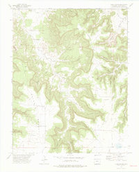
1972 Map of Plum Canyon
USGS Topo · Published 1975About this map
Morley and the surrounding rangelands of Las Animas County are defined here by an intricate network of drainages and isolated water sources. The landscape is carved by Plum Canyon and its many tributaries, including Deadman Canyon, Briggs Canyon, and School Section Canyon. This 1972 field-checked survey reveals the vital infrastructure of a high-desert environment, where family and ranch names are preserved through landmarks like Seven D Well, Plum Windmill, and Chapman Spring. Significant topographic features such as Courthouse Rock serve as natural markers above the winding Plum Creek. The presence of a single Grave and the site at Denton provide specific touchpoints for local historians and genealogists tracing the early occupation of this challenging terrain.
Find a feature on this map
39 named features on this map. Tap any name to fly to it.
Don’t see what you’re looking for? This feature index may not catch every label — zoom into the map to look around manually.
Map Details
Editions of this 1972 Plum Canyon Map
3 editions found

Other maps of this area

1891 · Higbee
USGS Topo · 1:125,000

1891 · Timpas
USGS Topo · 1:125,000

1891 · Mesa De Maya
USGS Topo · 1:125,000

1892 · Mt Carrizo
USGS Topo · 1:125,000

1893 · Higbee
USGS Topo · 1:125,000

1893 · Mesa de Maya
USGS Topo · 1:125,000

1894 · Timpas
USGS Topo · 1:125,000

1955 · La Junta
USGS Topo · 1:250,000

1958 · La Junta
USGS Topo · 1:250,000

1968 · La Junta
USGS Topo · 1:250,000