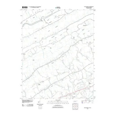
2010 Map of Plum Grove
USGS Topo · Published 2010About this map
Clinch Mountain and Robinette Mountain dominate the central topography of this Hawkins County region, creating a series of parallel ridges and valleys that have historically dictated the placement of settlements and transport routes. In the south, the Holston River carves the landscape near New Canton, where the presence of New Canton Siding along the rail corridor highlights the area's logistical importance. The map reveals a network of rural communities such as Greenland and Cold Springs, connected by a web of named country roads like Amis Chapel Rd and Fudges Chapel Rd, which often lead toward mountain passages like Plum Grove Gap. To the north, the Clinch River flows through Copper Ridge Valley, bordered by the smaller settlements of Flat Rock and Bellamytown. This intricate valley system, including Carter Valley and Stanley Valley, illustrates the enduring rural character of northeastern Tennessee.
Find a feature on this map
86 named features on this map. Tap any name to fly to it.
Don’t see what you’re looking for? This feature index may not catch every label — zoom into the map to look around manually.
Map Details
Editions of this 2010 Plum Grove Map
This is the sole edition of this map. No revisions or reprints were ever made.
Other maps of this area

1892 · Greeneville
USGS Topo · 1:125,000

1894 · Estillville
USGS Topo · 1:125,000

1896 · Greeneville
USGS Topo · 1:125,000

1904 · Greeneville
USGS Topo · 1:125,000

1935 · Surgoinsville
USGS Topo · 1:48,000

1935 · Lovelace
USGS Topo · 1:24,000

1935 · Moggasin
USGS Topo · 1:48,000

1935 · Looneys Gap
USGS Topo · 1:24,000

1935 · Clinchport
USGS Topo · 1:24,000
1935 · Duffield
USGS Topo · 1:24,000