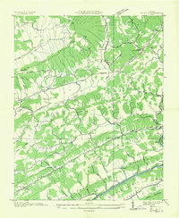
1935 Map of Duffield
USGS Topo · Published 1935About this map
Pattonsville and the surrounding Scott County landscape are defined by a series of parallel ridges including Powell Mountain and Purchase Ridge during the mid-1930s. The region is marked by a dense network of country schools and chapels, such as Pattonsville Sch and Mt View Ch, which served the rural population scattered across the deep hollows and gaps. The local economy and movement were tied to the North Fork Clinch River, where features like Powers Ford and Pierce Mill indicate the historic reliance on river crossings and water power. Transportation follows the grain of the land, with the Southern Railway and U S Highway Nos 23 & 58 cutting through the terrain near Duffield. The presence of several sinkholes near Duffield Sch reflects the distinct limestone topography of this corner of Virginia.
Find a feature on this map
57 named features on this map. Tap any name to fly to it.
Don’t see what you’re looking for? This feature index may not catch every label — zoom into the map to look around manually.
Map Details
Editions of this 1935 Duffield Map
This is the sole edition of this map. No revisions or reprints were ever made.
Other maps of this area

1894 · Estillville
USGS Topo · 1:125,000

1920 · Wise
USGS Topo · 1:48,000

1921 · Big Stone Gap
USGS Topo · 1:48,000

1921 · Wise
USGS Topo · 1:62,500

1922 · Big Stone Gap
USGS Topo · 1:62,500

1929 · Big Stone Gap
USGS Topo · 1:62,500

1935 · Moggasin
USGS Topo · 1:48,000

1935 · Looneys Gap
USGS Topo · 1:24,000

1935 · East Stone Gap
USGS Topo · 1:24,000
1935 · Keokee
USGS Topo · 1:24,000