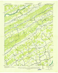
1935 Map of Plum Grove
USGS Topo · Published 1935About this map
Clinch River and the Holston River define the northern and southern bounds of this 1935 landscape, which captures a rural corridor spanning the Tennessee and Virginia border. The terrain is structured by a series of parallel ridges and valleys, including Copper Ridge, Clinch Mountain, and Pine Ridge, which dictate the placement of small communities and farmsteads. Local life is anchored by numerous country churches and schools, such as Amos Chapel, Bethel Ch, and Sunrise Sch, often situated along the winding valley roads.
Find a feature on this map
78 named features on this map. Tap any name to fly to it.
Don’t see what you’re looking for? This feature index may not catch every label — zoom into the map to look around manually.
Map Details
Editions of this 1935 Plum Grove Map
This is the sole edition of this map. No revisions or reprints were ever made.
Other maps of this area

1892 · Greeneville
USGS Topo · 1:125,000

1894 · Estillville
USGS Topo · 1:125,000

1896 · Greeneville
USGS Topo · 1:125,000

1904 · Greeneville
USGS Topo · 1:125,000

1935 · Surgoinsville
USGS Topo · 1:48,000

1935 · Lovelace
USGS Topo · 1:24,000

1935 · Moggasin
USGS Topo · 1:48,000

1935 · Looneys Gap
USGS Topo · 1:24,000

1935 · Clinchport
USGS Topo · 1:24,000
1935 · Duffield
USGS Topo · 1:24,000