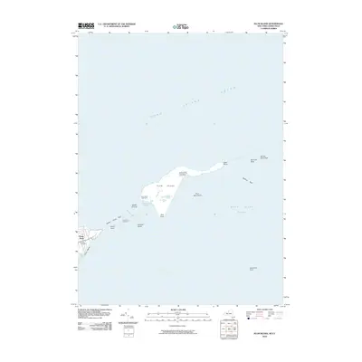
2010 Map of Plum Island
USGS Topo · Published 2010About this map
Plum Island sits at the critical junction of Long Island Sound, Block Island Sound, and Gardiners Bay. This coastal survey highlights the island's isolation and its significant role in national research, dominated by the United States Department of Agriculture facility. To the west, the tip of the North Fork is anchored by the settlement of Orient Point, where maritime history is preserved at the Latham Cemetery and the Orient Point Lighthouse. Navigational hazards such as Middle Ground and Midway Shoal define the treacherous waters of Plum Gut, a narrow passage essential for mariners. The map captures the island's unique 21st-century status as a restricted government enclave surrounded by rocky reefs like Bedford Reef and significant maritime landmarks including the Plum Island Lighthouse.
Find a feature on this map
25 named features on this map. Tap any name to fly to it.
Don’t see what you’re looking for? This feature index may not catch every label — zoom into the map to look around manually.
Map Details
Editions of this 2010 Plum Island Map
This is the sole edition of this map. No revisions or reprints were ever made.
Other maps of this area

1892 · New London
USGS Topo · 1:62,500

1893 · New London
USGS Topo · 1:62,500

1893 · Saybrook
USGS Topo · 1:62,500

1903 · Gardiners Island
USGS Topo · 1:62,500

1904 · Shelter Island
USGS Topo · 1:62,500

1904 · Gardiners Island
USGS Topo · 1:62,500

1921 · Gardiners Island
USGS Topo · 1:62,500

1921 · New London
USGS Topo · 1:62,500

1934 · Niantic
USGS Topo · 1:24,000

1938 · New London
USGS Topo · 1:31,680
Featured Places
- East Hampton, NY
- Southold, NY
- Orient, Southold
- Suffolk County, NY
- Southeastern Connecticut Planning Region, CT