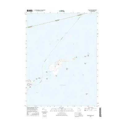
2016 Map of Plum Island
USGS Topo · Published 2016About this map
Plum Island sits prominently at the threshold of the Long Island Sound and the Atlantic Ocean, serving as a critical maritime waypoint in this 2016 survey. The map details the island's isolation, marked by Plum Gut Harbor and the surrounding Plum Gut, which separates it from the tip of Long Island. This area is defined by its navigation-heavy geography, where the Cross Sound Ferry line bisects the waters, connecting New York and Connecticut across the Suffolk County and New London County maritime border. On the mainland, the village of Orient and its peninsula extend toward Orient Point, illustrating the gateway to the Block Island Sound. The map also captures several distinct hazards and landmarks, including Old Silas Rock, Middle Shoal Rock, and the precarious Bedford Reef, providing a clear picture of the complex seafaring environment near The Sluiceway.
Find a feature on this map
32 named features on this map. Tap any name to fly to it.
Don’t see what you’re looking for? This feature index may not catch every label — zoom into the map to look around manually.
Map Details
Editions of this 2016 Plum Island Map
This is the sole edition of this map. No revisions or reprints were ever made.
Other maps of this area

1892 · New London
USGS Topo · 1:62,500

1893 · New London
USGS Topo · 1:62,500

1893 · Saybrook
USGS Topo · 1:62,500

1903 · Gardiners Island
USGS Topo · 1:62,500

1904 · Shelter Island
USGS Topo · 1:62,500

1904 · Gardiners Island
USGS Topo · 1:62,500

1921 · Gardiners Island
USGS Topo · 1:62,500

1921 · New London
USGS Topo · 1:62,500

1934 · Niantic
USGS Topo · 1:24,000

1938 · New London
USGS Topo · 1:31,680
Featured Places
- East Hampton, NY
- Southold, NY
- Orient, Southold
- Suffolk County, NY
- Southeastern Connecticut Planning Region, CT