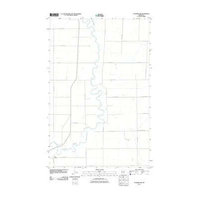
2010 Map of Plummer NW
USGS Topo · Published 2010About this map
The Red Lake River creates a serpentine path through this section of Pennington County, its tight oxbows and meanders defining the local landscape in the early 21st century. This region of northwest Minnesota is characterized by a strict grid of rural roads, including County Hwy-52 and County Hwy-2, which segment the flat agricultural terrain. A quiet cultural landmark, Saint Josephs Cemetery, sits in the southwestern corner along County Hwy-109, providing a specific point of interest for those researching local family histories. The presence of County Ditch Number Sixty in the southeast highlights the managed drainage systems essential to the area's land use. Large parcels of land are divided by thoroughfares like County Hwy-107 and 200th St SE, illustrating the intersection of natural river hydrology and human-imposed geometry.
Find a feature on this map
23 named features on this map. Tap any name to fly to it.
Don’t see what you’re looking for? This feature index may not catch every label — zoom into the map to look around manually.
Map Details
Editions of this 2010 Plummer NW Map
This is the sole edition of this map. No revisions or reprints were ever made.
Other maps of this area

1918 · Terrebonne
USGS Topo · 1:62,500

1918 · Red Lake Falls
USGS Topo · 1:62,500

1918 · Viking
USGS Topo · 1:62,500

1943 · Thief River Falls
USGS Topo · 1:62,500

1952 · Red Lake Falls
USGS Topo · 1:62,500

1952 · Grand Forks
USGS Topo · 1:250,000

1952 · Thief River Falls
USGS Topo · 1:250,000

1956 · Thief River Falls
USGS Topo · 1:250,000

1956 · Grand Forks
USGS Topo · 1:250,000

1957 · Thief River Falls
USGS Topo · 1:250,000