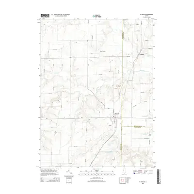
2015 Map of Plymouth
USGS Topo · Published 2015About this map
The village of Plymouth serves as the central hub of this West Central Illinois landscape, situated at the junction of Hancock, McDonough, and Schuyler Counties. This 2015 survey reveals a terrain defined by the winding course of the La Moine River and its numerous tributaries, including Bronson Creek, Panther Cr, and Flour Cr. The region's agricultural and rural heritage is evident in the cluster of small settlements like Saint Mary and Colmar, and the preservation of historic local burial grounds. Genealogists will find several notable family and community landmarks, such as Irwin Cem, Trimble Cem, Round Prairie Cem, and Davenport Cem. Water features such as Dennis Lake and Augusta Lake punctuate the southern landscape, while a dense grid of rural roads and county routes facilitates travel between the small towns and surrounding farmsteads.
Find a feature on this map
48 named features on this map. Tap any name to fly to it.
Don’t see what you’re looking for? This feature index may not catch every label — zoom into the map to look around manually.
Map Details
Editions of this 2015 Plymouth Map
This is the sole edition of this map. No revisions or reprints were ever made.
Other maps of this area

1913 · Colchester
USGS Topo · 1:62,500

1933 · Carthage
USGS Topo · 1:62,500

1937 · Carthage
USGS Topo · 1:62,500

1946 · Augusta
USGS Topo · 1:62,500

1948 · Camp Point
USGS Topo · 1:62,500

1949 · Augusta
USGS Topo · 1:62,500

1958 · Burlington
USGS Topo · 1:250,000

1961 · Burlington
USGS Topo · 1:250,000

1963 · Burlington
USGS Topo · 1:250,000
1974 · Bentley
USGS Topo · 1:24,000