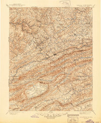
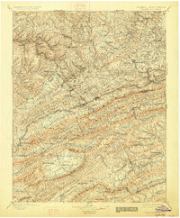
1895 Map of Pocahontas
USGS Topo · Published 1944About this map
Pocahontas stands as a central industrial hub in this late 19th-century survey, situated at the headwaters of the Bluestone River and the Tug Fork. The terrain is dominated by a succession of high ridges and narrow valleys, where the Norfolk and Western RR winds through the gap at Bluefield to serve the expanding coal fields of the region. Notable is the unusual geological depression of Burkes Garden, a high valley enclosed by Garden Mountain, which stands in sharp contrast to the linear ridges of Clinch Mountain and Walker Mountain to the south. Along the Wolf Creek and Walker Creek corridors, small settlements like Rocky Gap and Hicksville dot the landscape, illustrating the early transport network that connected the Mercer and Tazewell county borderlands. The map captures a moment of intense topographical change as the railroad bridged the gap between the rural agrarian valleys and the industrial mining frontier.
Find a feature on this map
113 named features on this map. Tap any name to fly to it.
Don’t see what you’re looking for? This feature index may not catch every label — zoom into the map to look around manually.
Map Details
Editions of this 1895 Pocahontas Map
6 editions found

Other maps of this area

1887 · Pocahontas
USGS Topo · 1:125,000

1887 · Hinton
USGS Topo · 1:125,000

1889 · Hillsville
USGS Topo · 1:125,000

1889 · Wytheville
USGS Topo · 1:125,000

1890 · Dublin
USGS Topo · 1:125,000

1891 · Tazewell
USGS Topo · 1:125,000

1891 · Pocahontas
USGS Topo · 1:125,000

1891 · Dublin
USGS Topo · 1:125,000

1891 · Oceana
USGS Topo · 1:125,000

1891 · Abingdon
USGS Topo · 1:125,000