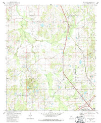
1980 Map of Pocahontas
USGS Topo · Published 1986About this map
Pocahontas Mounds and the adjacent Pocahontas Mounds Roadside Park anchor this landscape along the Madison and Hinds County line. The 1980 survey reveals a rural Mississippi territory transitioning toward suburban development, particularly evident in the Presidential Hills subdivision to the southeast. Grounded by a heavy concentration of community landmarks, the area is dotted with historical spiritual centers such as Mt Zion Ch, Bakers Grove Ch, and St Paul Ch.
Find a feature on this map
34 named features on this map. Tap any name to fly to it.
Don’t see what you’re looking for? This feature index may not catch every label — zoom into the map to look around manually.
Map Details
Editions of this 1980 Pocahontas Map
3 editions found
Other maps of this area

1903 · Jackson
USGS Topo · 1:125,000

1905 · Jackson
USGS Topo · 1:48,000

1908 · Jackson
USGS Topo · 1:62,500

1934 · Raymond
USGS Topo · 1:48,000

1937 · Raymond
USGS Topo · 1:62,500

1942 · Raymond
USGS Topo · 1:62,500

1955 · Jackson
USGS Topo · 1:250,000

1961 · Jackson
USGS Topo · 1:250,000

1961 · Canton
USGS Topo · 1:62,500

1962 · Jackson
USGS Topo · 1:250,000