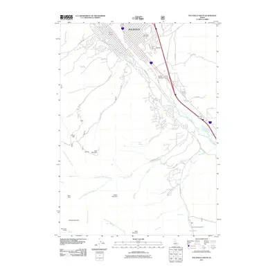
2011 Map of Pocatello South
USGS Topo · Published 2011About this map
Idaho State University anchors the northeastern corner of this 2011 landscape, where the urban grid of Pocatello meets the foothills of the Bannock Range. The town's expansion is visible along the Portneuf River corridor, flanked by the Bannock Hwy and Riverside Municipal Golf Course. Beyond the residential developments on Cedar Hills Dr, the terrain rises sharply toward Red Hill and the prominent Kinport Peak. The southern half of the quadrangle is defined by a dense network of canyons and ridges, including Gibson Mountain and Slate Mountain. This area is carved by numerous seasonal and perennial waterways such as Mink Creek, Gibson Jack Creek, and West Fork Mink Creek. This transition from the structured academic and civic spaces of the university and Mountain View Cemetery to the recreational areas like Cherry Springs Campground illustrates the city's relationship with its immediate wilderness surroundings.
Find a feature on this map
54 named features on this map. Tap any name to fly to it.
Don’t see what you’re looking for? This feature index may not catch every label — zoom into the map to look around manually.
Map Details
Editions of this 2011 Pocatello South Map
This is the sole edition of this map. No revisions or reprints were ever made.
Other maps of this area

1934 · Michaud
USGS Topo · 1:62,500

1937 · Pocatello
USGS Topo · 1:48,000

1937 · Michaud
USGS Topo · 1:62,500

1938 · Pauline
USGS Topo · 1:48,000

1944 · Pocatello
USGS Topo · 1:62,500

1944 · Arbon
USGS Topo · 1:62,500

1954 · Pocatello
USGS Topo · 1:250,000

1958 · Pocatello
USGS Topo · 1:250,000

1968 · Clifton Creek
USGS Topo · 1:24,000
1968 · Scout Mtn
USGS Topo · 1:24,000