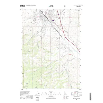
2020 Map of Pocatello South
USGS Topo · Published 2020About this map
The southern reaches of Pocatello unfold where the city's residential and institutional grid meets the rising slopes of the Caribou National Forest. This survey highlights the complex interface between the high-elevation peaks, including Kinport Peak and Slate Mtn, and the critical infrastructure following the Portneuf River valley. The presence of Idaho State University and the Bannock County Courthouse anchors the urban core, while the historic Union Pacific RR line tracks the narrow corridor along S 5th Ave.
Find a feature on this map
187 named features on this map. Tap any name to fly to it.
Don’t see what you’re looking for? This feature index may not catch every label — zoom into the map to look around manually.
Map Details
Editions of this 2020 Pocatello South Map
This is the sole edition of this map. No revisions or reprints were ever made.
Other maps of this area

1934 · Michaud
USGS Topo · 1:62,500

1937 · Pocatello
USGS Topo · 1:48,000

1937 · Michaud
USGS Topo · 1:62,500

1938 · Pauline
USGS Topo · 1:48,000

1944 · Pocatello
USGS Topo · 1:62,500

1944 · Arbon
USGS Topo · 1:62,500

1954 · Pocatello
USGS Topo · 1:250,000

1958 · Pocatello
USGS Topo · 1:250,000

1968 · Clifton Creek
USGS Topo · 1:24,000
1968 · Scout Mtn
USGS Topo · 1:24,000