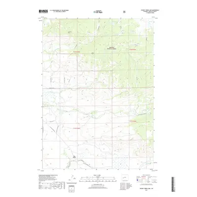
2017 Map of Pocket Creek Lake
USGS Topo · Published 2017About this map
Big Sandy sits at the southern edge of this landscape, where the high plains meet the transition into the Bridger National Forest. The area is defined by a series of high-altitude landmarks, including Chimney Butte and Aspen Butte, which overlook a complex network of waterways feeding into the E Fork River. This 2017 survey details a remote pocket of Sublette County dominated by glacial lakes and creek systems. To the north, Cottonwood Lake, Jim Lake, and Pocket Cr Lake serve as key hydrological features within the forest boundary. The map illustrates a network of primitive access routes, such as Pocket Creek Rd and the Big Sandy Elkhorn Rd, which trace the drainage basins of Irish Canyon Cr and Muddy Cr. These paths highlight the intersection of public land management and the rugged topography of western Wyoming.
Find a feature on this map
25 named features on this map. Tap any name to fly to it.
Don’t see what you’re looking for? This feature index may not catch every label — zoom into the map to look around manually.
Map Details
Editions of this 2017 Pocket Creek Lake Map
This is the sole edition of this map. No revisions or reprints were ever made.
Other maps of this area

1938 · Mt Bonneville
USGS Topo · 1:62,500

1941 · Mt Bonneville
USGS Topo · 1:62,500

1942 · Mt Bonneville
USGS Topo · 1:62,500

1955 · Lander
USGS Topo · 1:250,000

1958 · Lander
USGS Topo · 1:250,000

1961 · Lander
USGS Topo · 1:250,000

1964 · Fremont Butte
USGS Topo · 1:24,000
1964 · Square Top
USGS Topo · 1:24,000
1968 · Scab Creek
USGS Topo · 1:24,000

1969 · Pocket Creek Lake
USGS Topo · 1:24,000