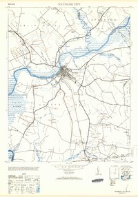
1953 Map of Pocomoke City
USGS Topo · Published 1953About this map
Pocomoke City serves as the focal point of this Eastern Shore survey, situated where the Pennsylvania railroad line crosses the winding Pocomoke River. The town's early mid-century infrastructure is visible through landmarks like the standpipe and cupola, while the surrounding landscape is defined by its relationship with the water and low-lying wetlands. The map details a network of family-named branches and swamps, including the expansive Cypress Swamp to the west and Beaverdam Swamp to the south.
Find a feature on this map
43 named features on this map. Tap any name to fly to it.
Don’t see what you’re looking for? This feature index may not catch every label — zoom into the map to look around manually.
Map Details
Editions of this 1953 Pocomoke City Map
2 editions found
Other maps of this area

1901 · Snow Hill
USGS Topo · 1:62,500

1942 · Kingston
USGS Topo · 1:24,000

1942 · Princess Anne
USGS Topo · 1:24,000

1942 · Snow Hill
USGS Topo · 1:24,000

1942 · Saxis
USGS Topo · 1:24,000

1942 · Dividing Creek
USGS Topo · 1:24,000

1943 · Snow Hill
USGS Topo · 1:31,680

1943 · Dividing Creek
USGS Topo · 1:31,680
1943 · Princess Anne
USGS Topo · 1:31,680

1943 · Saxis
USGS Topo · 1:31,680