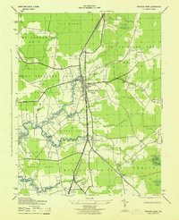
1943 Map of Princess Anne
USGS Topo · Published 1943About this map
Princess Anne serves as the focal point of this Somerset County survey, situated at the confluence of the Manokin River and the branching lines of the Pennsylvania railroad. During the early 1940s, the landscape was a mosaic of agricultural election districts and expansive wetlands like Tull Swamp and Dublin Swamp. The presence of a U. S. Army Camp south of Westover reflects the era's wartime mobilization, while institutional history is anchored by Princess Anne College and the Oakville School. The map captures a detailed transportation network where the Pennsylvania (Crisfield Branch) splits toward the coast. Rural life is evidenced by small settlements such as Kings Creek and Palmetto, alongside land-management areas like the Wellington Wildlife Demonstration Area. Meandering waterways, including Jones Creek and Monie Creek, define the low-lying terrain of Stewart Neck and Revels Neck.
Find a feature on this map
36 named features on this map. Tap any name to fly to it.
Don’t see what you’re looking for? This feature index may not catch every label — zoom into the map to look around manually.
Map Details
Editions of this 1943 Princess Anne Map
This is the sole edition of this map. No revisions or reprints were ever made.
Other maps of this area

1901 · Salisbury
USGS Topo · 1:62,500

1903 · Nanticoke
USGS Topo · 1:62,500

1903 · Deal Island
USGS Topo · 1:62,500

1942 · Marion
USGS Topo · 1:24,000

1942 · Monie
USGS Topo · 1:24,000

1942 · Wetipquin
USGS Topo · 1:24,000

1942 · Kingston
USGS Topo · 1:24,000

1942 · Princess Anne
USGS Topo · 1:24,000

1942 · Eden
USGS Topo · 1:24,000

1942 · Dividing Creek
USGS Topo · 1:24,000