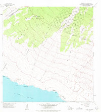
1962 Map of Pohue Bay
USGS Topo · Published 1972About this map
The Manuka Forest Reserve and adjacent volcanic slopes in Kahuku reveal a landscape shaped by successive eruptions. The massive Lava Flow of 1907 and Lava Flow of 1887 are prominent features, carving paths through the terrain toward the Pacific Ocean. These flows created Numerous kipukas—islands of older vegetation surrounded by younger lava—such as Kipuka Kanohina and Kipuka Pueo. Evidence of human activity is scattered across this geologically active zone, from the Petroglyphs near Puu Ki to the Manuka Mauka House near Manuka State Park.
Find a feature on this map
59 named features on this map. Tap any name to fly to it.
Don’t see what you’re looking for? This feature index may not catch every label — zoom into the map to look around manually.
Map Details
Editions of this 1962 Pohue Bay Map
3 editions found

Other maps of this area

1924 · Kalae
USGS Topo · 1:62,500

1924 · Honuapo
USGS Topo · 1:62,500

1928 · Hoopuloa
USGS Topo · 1:62,500

1954 · Hawaii South
USGS Topo · 1:250,000

1959 · Hawaii South
USGS Topo · 1:250,000

1961 · Hawaii South
USGS Topo · 1:250,000

1962 · Hawaii South
USGS Topo · 1:250,000

1962 · Milolii
USGS Topo · 1:24,000

1962 · Puu Hou
USGS Topo · 1:24,000

1962 · Kahuku Ranch
USGS Topo · 1:24,000