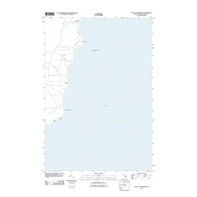
2011 Map of Point Aux Barques
USGS Topo · Published 2011About this map
Lake Michigan dominates the eastern half of this coastal survey, where the shoreline of Schoolcraft County is defined by a series of prominent landforms and small drainage networks. The coast is marked by jagged outcrops including Miller Point, Pillows Point, and Point Aux Barques, leading north toward the hazards of Wiggins Point Shoal. Inland, the landscape is shaped by several creeks such as Dead Horse Creek, Snyder Creek, and Gierke Creek that cut through the terrain to reach the lake. Human presence is concentrated along the coastal corridor, centered on the Woodstar Beach Campground and a network of local tracks like Hidden Shores Rd and Wiggins Point Rd. The map details a transition from the riparian environments of Bursaw Creek and Tebo Creek to the larger promontories like Bourassas Point, illustrating the geographic character of the Upper Peninsula shoreline.
Find a feature on this map
21 named features on this map. Tap any name to fly to it.
Don’t see what you’re looking for? This feature index may not catch every label — zoom into the map to look around manually.
Map Details
Editions of this 2011 Point Aux Barques Map
This is the sole edition of this map. No revisions or reprints were ever made.
Other maps of this area

1931 · Cooks NE
USGS Topo · 1:31,680

1931 · Cooks NW
USGS Topo · 1:31,680

1954 · Escanaba
USGS Topo · 1:250,000

1957 · Escanaba
USGS Topo · 1:250,000

1958 · Escanaba
USGS Topo · 1:250,000

1958 · Cooks
USGS Topo · 1:62,500
1972 · Manistique East
USGS Topo · 1:24,000

1983 · Manistique
USGS Topo · 1:100,000
1983 · Cooks
USGS Topo · 1:25,000
1983 · Manistique West
USGS Topo · 1:25,000