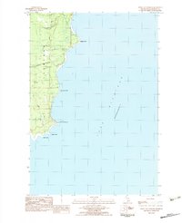
1983 Map of Point Aux Barques
USGS Topo · Published 1984About this map
Thompson park and the winding coast of Lake Michigan define this Lake-era survey of Schoolcraft County. The landscape is characterized by its numerous small waterways, including the curiously named Dead Horse Creek, Snyder Creek, and Gierke Creek, which all drain toward the irregular shoreline. This map illustrates the intersection of industrial use and natural terrain, showing several Gravel Pits and the primary transit corridor of Little Harbor Road. Several named geographic projections, such as Wiggins Point, Bourassas Point, and the eponymous Point aux Barques, provide specific landmarks for maritime and local history researchers. The presence of sand deposits and varying coastal elevations highlights the shifting nature of the shoreline before modern developments changed the local topography.
Find a feature on this map
18 named features on this map. Tap any name to fly to it.
Don’t see what you’re looking for? This feature index may not catch every label — zoom into the map to look around manually.
Map Details
Editions of this 1983 Point Aux Barques Map
This is the sole edition of this map. No revisions or reprints were ever made.
Other maps of this area

1931 · Cooks NE
USGS Topo · 1:31,680

1931 · Cooks NW
USGS Topo · 1:31,680

1954 · Escanaba
USGS Topo · 1:250,000

1957 · Escanaba
USGS Topo · 1:250,000

1958 · Escanaba
USGS Topo · 1:250,000

1958 · Cooks
USGS Topo · 1:62,500
1972 · Manistique East
USGS Topo · 1:24,000

1983 · Manistique
USGS Topo · 1:100,000
1983 · Cooks
USGS Topo · 1:25,000
1983 · Manistique West
USGS Topo · 1:25,000