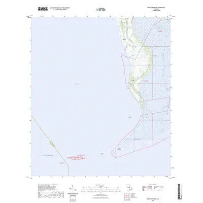
2024 Map of Point Chevreuil
USGS Topo · Published 2024About this map
Bayou Sale Bay and East Cote Blanche Bay meet at the marshy southern terminus of St. Mary Parish, where the land fragments into a complex network of wetlands and tidal channels. Small settlements like Burns and Gordy are perched along the higher ground of the W Bayou Sale Levee and E Bayou Sale Levee, which provide a narrow corridor for infrastructure such as State Rte 317. This coastal landscape is heavily defined by energy transit, as evidenced by United Gas Ln and Mobil Oil Ln cutting through the marsh. To the south, prominent natural features include Point Chevreuil and Rabbit Island, while local genealogy is grounded by the South Bend Cem near the northern map edge. The map captures the delicate balance between the industrial demand for resource access and the encroaching waters of the Gulf of Mexico.
Find a feature on this map
33 named features on this map. Tap any name to fly to it.
Don’t see what you’re looking for? This feature index may not catch every label — zoom into the map to look around manually.
Map Details
Editions of this 2024 Point Chevreuil Map
This is the sole edition of this map. No revisions or reprints were ever made.
Other maps of this area

1935 · Belle Isle
USGS Topo · 1:31,680

1937 · Bayou Sale
USGS Topo · 1:62,500

1941 · Belle Isle
USGS Topo · 1:62,500

1945 · New Orleans
USGS Topo · 1:250,000
1951 · Lake Point
USGS Topo · 1:24,000

1954 · Belle Isle
USGS Topo · 1:62,500

1957 · Bayou Sale
USGS Topo · 1:62,500

1957 · Point Au Fer
USGS Topo · 1:62,500

1963 · New Orleans
USGS Topo · 1:250,000

1966 · New Orleans
USGS Topo · 1:250,000