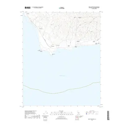
2018 Map of Point Conception
USGS Topo · Published 2018About this map
Point Conception anchors this coastal topography, marking the dramatic bend where the California shoreline turns sharply eastward into Cojo Bay. The landscape is defined by the steep southern slopes of the Santa Ynez Mountains, which are dissected by numerous drainages such as Wood Canyon and Damsite Canyon. Local transit is centered on the winding Cojo Bay Rd and Cojo Rd, which provide access to the small settlement at Concepcion and the rocky promontory at Government Point. Along the coast, distinct landmarks like Indian Head Rock and the deep incision of Barranca Honda illustrate the complex interface between the mountains and the Pacific Ocean. Further inland, the presence of Cañada Del Cementerio suggests early cultural and settlement history tucked within the coastal hills, while water sources like Las Animas Spring hint at the necessities for life in this isolated terrain.
Find a feature on this map
29 named features on this map. Tap any name to fly to it.
Don’t see what you’re looking for? This feature index may not catch every label — zoom into the map to look around manually.
Map Details
Editions of this 2018 Point Conception Map
This is the sole edition of this map. No revisions or reprints were ever made.
Other maps of this area

1905 · Guadalupe
USGS Topo · 1:125,000

1905 · Lompoc
USGS Topo · 1:125,000

1942 · Point Arguello
USGS Topo · 1:62,500

1942 · Guadalupe
USGS Topo · 1:125,000

1942 · Lompoc
USGS Topo · 1:125,000

1942 · Lompoc
USGS Topo · 1:62,500

1942 · Pt. Conception
USGS Topo · 1:62,500

1943 · Lompoc
USGS Topo · 1:125,000
1947 · Santa Rosa Hills
USGS Topo · 1:24,000
1947 · El Tranquillon
USGS Topo · 1:24,000