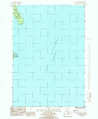
1985 Map of Point Detour
USGS Topo · Published 1985About this map
Point Detour and the northern tip of Summer Island define this coastal landscape at the entrance to Big Bay de Noc in the mid-1980s. This transitional maritime zone is largely preserved within the Fairbanks Lake Superior State Forest, where the land meets the vast expanse of Lake Michigan. The map records an approximate mean lake elevation of 177.0 meters, providing a precise baseline for the shoreline as it existed during this survey period. With very little human development shown beyond township boundaries like t37n-r19w, the sheet emphasizes the natural geography of the Delta County coastline and its relation to the surrounding Great Lakes waters, including a small labeled portion of Lake Superior in the northwestern corner.
Find a feature on this map
7 named features on this map. Tap any name to fly to it.
Don’t see what you’re looking for? This feature index may not catch every label — zoom into the map to look around manually.
Map Details
Editions of this 1985 Point Detour Map
This is the sole edition of this map. No revisions or reprints were ever made.
Other maps of this area

1932 · Burnt Bluff SW
USGS Topo · 1:31,680

1932 · Burnt Bluff NE
USGS Topo · 1:31,680

1932 · Burnt Bluff NW
USGS Topo · 1:31,680

1954 · Escanaba
USGS Topo · 1:250,000

1957 · Escanaba
USGS Topo · 1:250,000

1958 · Escanaba
USGS Topo · 1:250,000

1958 · Fairport
USGS Topo · 1:62,500

1983 · Manistique
USGS Topo · 1:100,000

1984 · Washington Island
USGS Topo · 1:100,000
1985 · Devils Corner
USGS Topo · 1:24,000