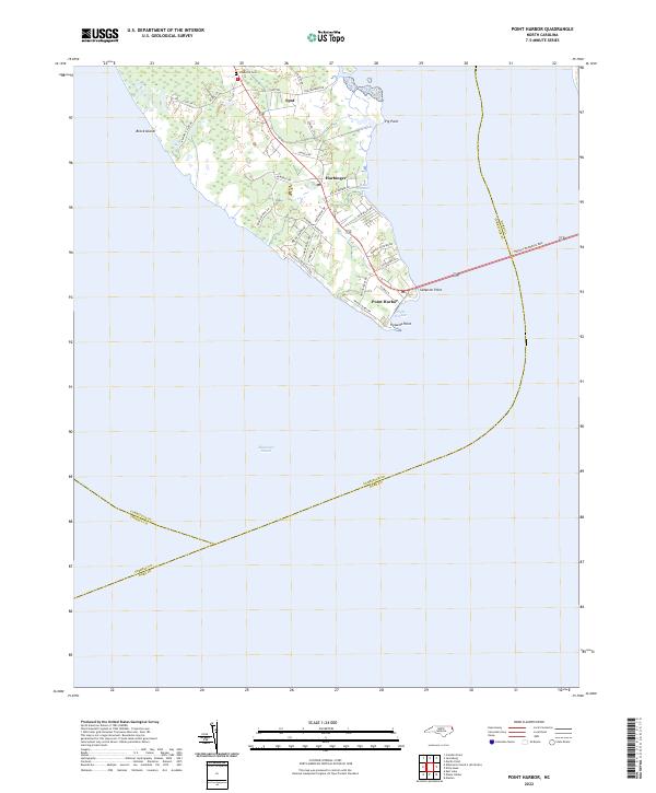
2022 Map of Point Harbor
USGS Topo · Published 2022About this map
Point Harbor sits at the southern tip of the peninsula where the Wright Memorial Brg stretches across the water toward the Outer Banks. This coastal survey detail highlights the low-lying geography of the region, defined by the expansive Albemarle Sound and smaller inlets like Halls Harbor. Settlements including Harbinger and Spot are shown along the central corridor of the peninsula, which is flanked by marshy terrain and geographic markers such as Brock Island and Pig Point. Local history is anchored by sites like Chadwick Cem, while the road network reaching toward Powells Point illustrates the area's role as a vital transit point. The map reflects a landscape where maritime influence and modern infrastructure intersect at the gateway to the North Carolina coast.
Find a feature on this map
37 named features on this map. Tap any name to fly to it.
Don’t see what you’re looking for? This feature index may not catch every label — zoom into the map to look around manually.
Map Details
Editions of this 2022 Point Harbor Map
This is the sole edition of this map. No revisions or reprints were ever made.
Other maps of this area

1940 · Kitty Hawk
USGS Topo · 1:62,500

1940 · Powells Point
USGS Topo · 1:62,500

1943 · Roanoke Island
USGS Topo · 1:125,000

1946 · Eastville
USGS Topo · 1:250,000

1946 · Currituck Sound
USGS Topo · 1:250,000

1953 · Manteo
USGS Topo · 1:24,000

1953 · Manns Harbor
USGS Topo · 1:24,000
1953 · East Lake
USGS Topo · 1:24,000

1955 · Wanchese
USGS Topo · 1:250,000

1957 · Manteo
USGS Topo · 1:250,000