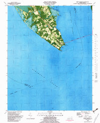
1982 Map of Point Harbor
USGS Topo · Published 1983About this map
Point Harbor sits at the southern tip of the Currituck peninsula, where the waters of the Currituck Sound meet the Albemarle Sound. This 1982 orthophotomap provides a clear view of the thin finger of land that serves as the gateway to the Outer Banks, anchored by the long reach of the Wright Memorial Bridge. Small residential clusters and agricultural clearings are centered around the communities of Spot and Harbinger, while several unnamed Cem locations scattered throughout the interior offer potential leads for genealogists and local historians. The shoreline is characterized by marshy transitions, including the Tidal Flat near Hog Quarter Landing and the distinctive hook of Sampson Point. The presence of a Sandpit and a Radio Tower reflect the utility of the landscape during this era of coastal development.
Find a feature on this map
19 named features on this map. Tap any name to fly to it.
Don’t see what you’re looking for? This feature index may not catch every label — zoom into the map to look around manually.
Map Details
Editions of this 1982 Point Harbor Map
This is the sole edition of this map. No revisions or reprints were ever made.
Other maps of this area

1940 · Kitty Hawk
USGS Topo · 1:62,500

1940 · Powells Point
USGS Topo · 1:62,500

1943 · Roanoke Island
USGS Topo · 1:125,000

1946 · Eastville
USGS Topo · 1:250,000

1946 · Currituck Sound
USGS Topo · 1:250,000

1953 · Manteo
USGS Topo · 1:24,000

1953 · Manns Harbor
USGS Topo · 1:24,000
1953 · East Lake
USGS Topo · 1:24,000

1955 · Wanchese
USGS Topo · 1:250,000

1957 · Manteo
USGS Topo · 1:250,000