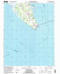
1999 Map of Point Harbor
USGS Topo · Published 2002About this map
Point Harbor sits at the southern tip of the Currituck peninsula, marking the critical junction where the Currituck Sound meets the Albemarle Sound. This 1999 inspection reflects the late-century configuration of the Outer Banks access points, anchored by the massive Wright Memorial Bridge stretching eastward toward the coast. The landscape is a mix of maritime forests and wetlands, with several small settlements such as Harbinger and Spot lining the interior highway. Local history is preserved in the location of Piney Grove Ch and several small clusters of Cemeteries near Powells Point. The shoreline is deeply indented with coastal features like Hog Quarter Landing and Sampson Point, illustrating the area's historical reliance on water access before modern bridge infrastructure dominated the geography.
Find a feature on this map
19 named features on this map. Tap any name to fly to it.
Don’t see what you’re looking for? This feature index may not catch every label — zoom into the map to look around manually.
Map Details
Editions of this 1999 Point Harbor Map
This is the sole edition of this map. No revisions or reprints were ever made.
Other maps of this area

1940 · Kitty Hawk
USGS Topo · 1:62,500

1940 · Powells Point
USGS Topo · 1:62,500

1943 · Roanoke Island
USGS Topo · 1:125,000

1946 · Eastville
USGS Topo · 1:250,000

1946 · Currituck Sound
USGS Topo · 1:250,000

1953 · Manteo
USGS Topo · 1:24,000

1953 · Manns Harbor
USGS Topo · 1:24,000
1953 · East Lake
USGS Topo · 1:24,000

1955 · Wanchese
USGS Topo · 1:250,000

1957 · Manteo
USGS Topo · 1:250,000