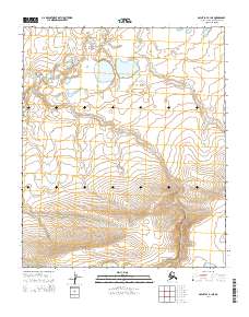
2014 Map of Point Lay B-1 NE
USGS Topo · Published 2014About this map
North Slope topography in this remote Arctic region is defined by a landscape of low-lying coastal plains and subtle ridgelines, organized into the Public Land Survey System grids of T2n R42w and T2n R41w. The terrain is characterized by a complex network of thaw lakes and drainage basins that illustrate the permafrost-driven hydrology of northern Alaska. Moving south through T1n R42w and T1n R41w, the contour intervals reveal the gradual transition from the watery tundra toward the foothills, providing a clear record of the area's natural drainage patterns before modern environmental shifts. This 2014 survey captures the precise township and range divisions, including T1s R43w and T1s R42w, offering an essential geographic baseline for this largely uninhabited portion of the Arctic slope.
Find a feature on this map
6 named features on this map. Tap any name to fly to it.
Don’t see what you’re looking for? This feature index may not catch every label — zoom into the map to look around manually.
Map Details
Editions of this 2014 Point Lay B-1 NE Map
This is the sole edition of this map. No revisions or reprints were ever made.
Other maps of this area

1951 · Utukok River
USGS Topo · 1:250,000

1951 · Point Lay
USGS Topo · 1:250,000

1955 · Point Lay
USGS Topo · 1:250,000
1955 · Utukok River C-5
USGS Topo · 1:63,360

1955 · Point Lay B-1
USGS Topo · 1:63,360

1955 · Point Lay C-1
USGS Topo · 1:63,360
1955 · Utukok River B-5
USGS Topo · 1:63,360

1956 · Utukok River
USGS Topo · 1:250,000

1965 · Utukok River
USGS Topo · 1:250,000

1965 · Point Lay
USGS Topo · 1:250,000