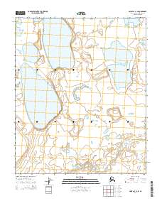
2014 Map of Point Lay C-1 SE
USGS Topo · Published 2014About this map
Tunusiktok Lake and Pugutak Lake dominate this section of the Arctic coastal plain in the North Slope Borough. This 2014 survey documents a landscape defined by expansive thaw lakes and slow-moving drainages like Niklavik Cr, which winds through the western portion of the quadrangle. The topography is exceptionally level, typical of the permafrost-underlain tundra where drainage patterns are often dictated by subtle changes in elevation between these large water bodies. Farther east, Mumik Lake sits within a network of smaller ponds and marshy depressions. The map clearly outlines the Public Land Survey System grids, including t3n r42w and t2n r41w, providing a framework for understanding land administration in this northern Alaskan environment.
Find a feature on this map
8 named features on this map. Tap any name to fly to it.
Don’t see what you’re looking for? This feature index may not catch every label — zoom into the map to look around manually.
Map Details
Editions of this 2014 Point Lay C-1 SE Map
This is the sole edition of this map. No revisions or reprints were ever made.
Other maps of this area

1951 · Utukok River
USGS Topo · 1:250,000

1951 · Point Lay
USGS Topo · 1:250,000

1955 · Point Lay
USGS Topo · 1:250,000
1955 · Utukok River C-5
USGS Topo · 1:63,360

1955 · Point Lay B-1
USGS Topo · 1:63,360

1955 · Point Lay C-1
USGS Topo · 1:63,360
1955 · Utukok River B-5
USGS Topo · 1:63,360

1956 · Utukok River
USGS Topo · 1:250,000

1965 · Utukok River
USGS Topo · 1:250,000

1965 · Point Lay
USGS Topo · 1:250,000