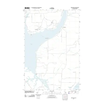
2011 Map of Point Mills
USGS Topo · Published 2011About this map
Senter and Point Mills anchor this coastal landscape in the Keweenaw Peninsula, where the waters of Torch Bay and Portage Lake meet. The geography is defined by a series of points and shoals, such as Grosse Point, Princess Point, and the underwater hazards of Lamirande Shoal. To the south, a complex network of waterways including the Sturgeon River, Snake River, and the Old Channel drain into the Portage River as it reaches towards Lake Superior. This 2011 survey illustrates the modern road network, including Jacobsville Rd and Bootjack Rd, which connect the scattered settlements and local landmarks like the Jacobsville Cemetery. The presence of Stone Quarry Lake and numerous local creeks like Silver Creek and Le Chance Creek highlights the drainage patterns of this lakefront environment, reflecting a community shaped by its proximity to the water and its historical industrial footprints.
Find a feature on this map
46 named features on this map. Tap any name to fly to it.
Don’t see what you’re looking for? This feature index may not catch every label — zoom into the map to look around manually.
Map Details
Editions of this 2011 Point Mills Map
This is the sole edition of this map. No revisions or reprints were ever made.
Other maps of this area

1915 · Houghton
USGS Topo · 1:62,500

1946 · Hancock
USGS Topo · 1:24,000

1946 · Chassell
USGS Topo · 1:24,000

1946 · Laurium
USGS Topo · 1:24,000

1948 · Laurium
USGS Topo · 1:24,000

1948 · Hancock
USGS Topo · 1:24,000

1948 · Chassell
USGS Topo · 1:24,000

1954 · Traverse Island
USGS Topo · 1:24,000
1954 · Rice Lake
USGS Topo · 1:24,000

1954 · Keweenaw Bay
USGS Topo · 1:62,500