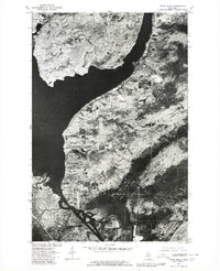
1978 Map of Point Mills
USGS Topo · Published 1980About this map
Dollar Bay and the surrounding industrial landscape of Michigan's Keweenaw Peninsula are captured in this late 1970s orthophotoquad. The imagery provides a raw look at the shoreline along Portage Lake, where the small settlements of Senter and Point Mills sit amidst a patchwork of forested sections and cleared land. This specific format, a collaboration between the U.S. Geological Survey and the Soil Conservation Service, emphasizes the actual ground cover and land use patterns of the era rather than just traditional topographic contours.
Find a feature on this map
7 named features on this map. Tap any name to fly to it.
Don’t see what you’re looking for? This feature index may not catch every label — zoom into the map to look around manually.
Map Details
Editions of this 1978 Point Mills Map
This is the sole edition of this map. No revisions or reprints were ever made.
Other maps of this area

1915 · Houghton
USGS Topo · 1:62,500

1946 · Hancock
USGS Topo · 1:24,000

1946 · Chassell
USGS Topo · 1:24,000

1946 · Laurium
USGS Topo · 1:24,000

1948 · Laurium
USGS Topo · 1:24,000

1948 · Hancock
USGS Topo · 1:24,000

1948 · Chassell
USGS Topo · 1:24,000

1954 · Traverse Island
USGS Topo · 1:24,000
1954 · Rice Lake
USGS Topo · 1:24,000

1954 · Keweenaw Bay
USGS Topo · 1:62,500
Featured Places
- Torch Lake Township, MI
- Portage Township, MI
- Chassell Township, MI
- Osceola Township, MI
- Dreamland, Torch Lake Township