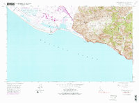
1949 Map of Point Mugu
USGS Topo · Published 1987About this map
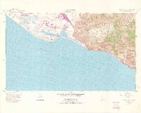
Mugu Lagoon dominates the coastline of this Southern California survey, serving as a critical transition between the waters of the Pacific Ocean and the steep slopes of the Santa Monica Mts. The terrain is characterized by a sharp division between the low-lying Rio De Santa Clara delta, featuring Duck Ponds and agricultural markers like a Windmill, and the elevated interior peaks such as Laguna Pk and Mugu Pk. This mid-century landscape reflects the early footprint of the Pacific Missile Range, showing the integration of military infrastructure within the natural coastal geography.
Find a feature on this map
24 named features on this map. Tap any name to fly to it.
Don’t see what you’re looking for? This feature index may not catch every label — zoom into the map to look around manually.
Map Details
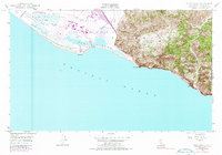
Editions of this 1949 Point Mugu Map
6 editions found
Other maps of this area

1900 · Triunfo Pass
USGS Topo · 1:62,500

1903 · Camulos
USGS Topo · 1:125,000

1904 · Hueneme
USGS Topo · 1:62,500

1921 · Triunfo Pass
USGS Topo · 1:62,500

1932 · Arroyo Sequit
USGS Topo · 1:24,000

1942 · Hueneme
USGS Topo · 1:62,500

1943 · Hueneme
USGS Topo · 1:62,500
1943 · Triunfo Pass
USGS Topo · 1:62,500

1949 · Los Angeles
USGS Topo · 1:250,000

1949 · Oxnard
USGS Topo · 1:24,000