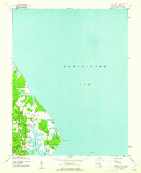
1943 Map of Point No Point
USGS Topo · Published 1962About this map
St Jerome Neck defines this coastal landscape on the western shore of the Chesapeake Bay, where tidal inlets and small ponds create a complex shoreline. Mapped from aerial photography taken in 1942, the topography reveals a rural Maryland peninsula characterized by the deep indentation of St Jerome Creek and the quiet settlement at Dameron. The survey captures the area just before mid-century development, showing the proximity of maritime life to the inland woods and fields. Small water bodies like Biscue Pond, Carroll Pond, and Filbert Pond are scattered across the neck, emphasizing the saturated nature of the local terrain. Off the coast, a lonely Lighthouse stands watch near Point No Point, marking a critical navigation spot for bay traffic during the war years.
Find a feature on this map
15 named features on this map. Tap any name to fly to it.
Don’t see what you’re looking for? This feature index may not catch every label — zoom into the map to look around manually.
Map Details
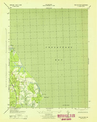
Editions of this 1943 Point No Point Map
2 editions found
Other maps of this area

1892 · Drum Point
USGS Topo · 1:62,500

1894 · Point Lookout
USGS Topo · 1:62,500

1898 · St. Marys
USGS Topo · 1:125,000

1901 · Drum Point
USGS Topo · 1:62,500

1903 · Bloodsworth Island
USGS Topo · 1:62,500

1905 · Crapo
USGS Topo · 1:62,500

1905 · Drum Point
USGS Topo · 1:62,500

1906 · St. Marys
USGS Topo · 1:125,000

1912 · Point Lookout
USGS Topo · 1:62,500

1937 · Point Lookout
USGS Topo · 1:62,500