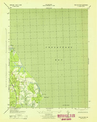
1943 Map of Point No Point
USGS Topo · Published 1943About this map
St Jerome Neck and the surrounding lowlands of St. Mary's County are meticulously documented in this 1943 survey, conducted by the War Department and Corps of Engineers. The map details a landscape where the Chesapeake Bay deeply carves into the shoreline, creating complex waterways like St Jerome Creek and Malone Bay. This era of documentation shows the rural character of southern Maryland during the war, focusing on the infrastructure of the St Inigoes district and the primary transit artery of Three Notch Road. The importance of maritime navigation is evident with the offshore Point No Point Lighthouse, while inland features such as Blue Gull Mill and the settlement at Dameron reveal the local economy of the time. These coastal wetlands, punctuated by Biscue Pond and Filbert Pond, reflect a region defined by its close relationship with the bay.
Find a feature on this map
20 named features on this map. Tap any name to fly to it.
Don’t see what you’re looking for? This feature index may not catch every label — zoom into the map to look around manually.
Map Details
Editions of this 1943 Point No Point Map
2 editions found
Other maps of this area

1892 · Drum Point
USGS Topo · 1:62,500

1894 · Point Lookout
USGS Topo · 1:62,500

1898 · St. Marys
USGS Topo · 1:125,000

1901 · Drum Point
USGS Topo · 1:62,500

1903 · Bloodsworth Island
USGS Topo · 1:62,500

1905 · Crapo
USGS Topo · 1:62,500

1905 · Drum Point
USGS Topo · 1:62,500

1906 · St. Marys
USGS Topo · 1:125,000

1912 · Point Lookout
USGS Topo · 1:62,500

1937 · Point Lookout
USGS Topo · 1:62,500