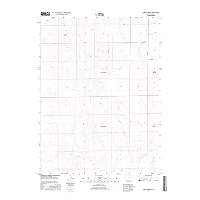
2016 Map of Point of Rocks
USGS Topo · Published 2016About this map
Point of Rocks rises as the defining topographic landmark of this High Plains landscape, situated within the expansive grid of the Public Land Survey System. The area is characterized by its agricultural organization, with townships such as t6n r62w and t5n r62w meticulously divided by an established network of county roads. Drainage in this arid environment is channeled through ephemeral features like Sanborn Draw, which cuts through the northeastern reaches of the quadrangle. The map captures the interplay between the natural contours of the northern Colorado terrain and the rigid human geometry of the range and township system, illustrating how transportation corridors like Co Rd 70 and Co Rd 68 follow section lines to connect this rural territory.
Find a feature on this map
14 named features on this map. Tap any name to fly to it.
Don’t see what you’re looking for? This feature index may not catch every label — zoom into the map to look around manually.
Map Details
Editions of this 2016 Point of Rocks Map
This is the sole edition of this map. No revisions or reprints were ever made.
Other maps of this area

1950 · Greasewood Lake
USGS Topo · 1:24,000

1950 · Barnesville
USGS Topo · 1:24,000

1950 · Masters
USGS Topo · 1:24,000

1950 · Hardin
USGS Topo · 1:24,000

1951 · Masters
USGS Topo · 1:24,000

1951 · Hardin
USGS Topo · 1:24,000

1951 · Point Of Rocks
USGS Topo · 1:24,000
1951 · Dearfield
USGS Topo · 1:24,000

1954 · Greeley
USGS Topo · 1:250,000

1957 · Greeley
USGS Topo · 1:250,000