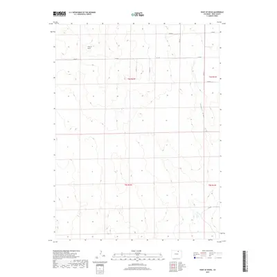
2019 Map of Point of Rocks
USGS Topo · Published 2019About this map
Point of Rocks rises as a prominent landmark above the surrounding high plains of Weld County, defining the western portion of this landscape. The terrain is marked by the drainage of Sanborn Draw, which cuts through the eastern sections of the quadrangle. This 2019 survey by the U.S. Geological Survey illustrates a modern rural grid system, primarily defined by a network of county roads including Co Rd 70, Co Rd 68, and Co Rd 85. The map provides a precise look at the Public Land Survey System divisions, spanning several townships such as t6n r62w and t5n r61w. This is a landscape of expansive open space, where elevation changes are represented by ten-foot contour intervals, capturing the subtle undulations of the Colorado prairie and the natural basins that characterize this part of the Front Range hinterland.
Find a feature on this map
14 named features on this map. Tap any name to fly to it.
Don’t see what you’re looking for? This feature index may not catch every label — zoom into the map to look around manually.
Map Details
Editions of this 2019 Point of Rocks Map
This is the sole edition of this map. No revisions or reprints were ever made.
Other maps of this area

1950 · Greasewood Lake
USGS Topo · 1:24,000

1950 · Barnesville
USGS Topo · 1:24,000

1950 · Masters
USGS Topo · 1:24,000

1950 · Hardin
USGS Topo · 1:24,000

1951 · Masters
USGS Topo · 1:24,000

1951 · Hardin
USGS Topo · 1:24,000

1951 · Point Of Rocks
USGS Topo · 1:24,000
1951 · Dearfield
USGS Topo · 1:24,000

1954 · Greeley
USGS Topo · 1:250,000

1957 · Greeley
USGS Topo · 1:250,000