
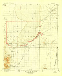
1916 Map of Point Of Sands
USGS Topo · Published 1916About this map
White Sands and the vast Alkali Flat dominate this 1916 survey of the Tularosa Basin, revealing a landscape defined by water scarcity and ranching endurance. Scattered throughout the arid basin floor are numerous family-named landmarks like Bairds Ranch and McNew Ranch, which served as critical hubs of activity before the region became a closed military range. To the west, the San Andres Mountains rise sharply, providing a source for San Nicolas Spring and Bennett Camp. This era captures early industrial interests such as the Eddy Soda Prospect near Lake Lucero, while the El Paso and Southwestern railroad cuts through the eastern edge at Escondida, connecting this remote basin to the broader regional economy.
Find a feature on this map
28 named features on this map. Tap any name to fly to it.
Don’t see what you’re looking for? This feature index may not catch every label — zoom into the map to look around manually.
Map Details
Editions of this 1916 Point Of Sands Map
2 editions found
Other maps of this area

1891 · Las Cruces
USGS Topo · 1:125,000

1893 · Las Cruces
USGS Topo · 1:125,000

1916 · Tonuco
USGS Topo · 1:125,000

1916 · Salinas Peak
USGS Topo · 1:125,000

1916 · Tularosa
USGS Topo · 1:125,000

1932 · Tonuco
USGS Topo · 1:125,000

1940 · Orogrande
USGS Topo · 1:62,500

1941 · Organ Peak
USGS Topo · 1:62,500

1943 · Parker Lake
USGS Topo · 1:62,500

1943 · Pendejo Wash
USGS Topo · 1:62,500