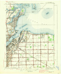
1938 Map of Point Place
USGS Topo · Published 1938About this map
Maumee Bay and the mouth of the Maumee River define this 1930s coastal landscape where industrial infrastructure meets recreational shoreline. The eastern shore of the river is dominated by the Homestead Yard and the Ironville neighborhood, illustrating the intense railroad and shipping activity that fueled the region. In contrast, the northern peninsula of Point Place and the surrounding beaches like Willow Beach and Carland Beach show a community oriented toward the water, with the Naval Armory, Toledo Yacht Club, and a waterfront golf course establishing it as a social hub. Further inland, the township of Oregon transitions into a grid of agricultural and rural residential plots. Landmarks such as Pearson State Park and St Marks Ch provide a sense of local community life, while the Ohio Public Service (Electric) Road highlights the early infrastructure connecting these lakefront settlements to the broader Ohio-Michigan borderlands.
Find a feature on this map
66 named features on this map. Tap any name to fly to it.
Don’t see what you’re looking for? This feature index may not catch every label — zoom into the map to look around manually.
Map Details
Editions of this 1938 Point Place Map
2 editions found
Other maps of this area

1900 · Maumee Bay
USGS Topo · 1:62,500

1900 · Toledo
USGS Topo · 1:62,500

1912 · Monroe
USGS Topo · 1:62,500

1912 · Dundee
USGS Topo · 1:62,500

1914 · Monroe
USGS Topo · 1:62,500

1926 · Dundee
USGS Topo · 1:62,500

1934 · Reno Beach
USGS Topo · 1:24,000

1934 · Point Place
USGS Topo · 1:24,000

1934 · Rossford
USGS Topo · 1:24,000

1935 · Walbridge
USGS Topo · 1:24,000