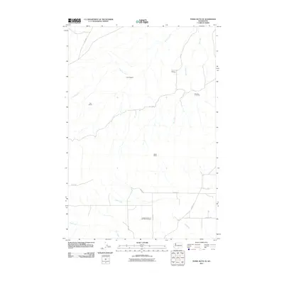
2011 Map of Poisel Butte SE
USGS Topo · Published 2011About this map
Beaver Cemetery and the Independent Order of Odd Fellows Cemetery anchor the southern reaches of this Yakima County landscape, providing essential touchstones for genealogical research in the region. The terrain is defined by a network of drainage systems, including the seasonally varying Mule Dry Creek, Mule Creek, and Alder Creek. The presence of Wandlings Lower Camp near the eastern margin suggests localized activity tied to the land, while prominent geological features like Mule Butte and The Island break the steady progression of the drainages. A grid of Bureau of Indian Affairs routes, such as Bia 31 RD and Bia 288 RD, crisscrosses the area, indicating the structured management of this territory. This 2011 survey captures the transition from the high canyons like Lucy Canyon down toward the southern flats along Pine Creek, documenting the placement of family and fraternal burial grounds within the open country.
Find a feature on this map
19 named features on this map. Tap any name to fly to it.
Don’t see what you’re looking for? This feature index may not catch every label — zoom into the map to look around manually.
Map Details
Editions of this 2011 Poisel Butte SE Map
This is the sole edition of this map. No revisions or reprints were ever made.
Other maps of this area

1910 · Zillah
USGS Topo · 1:125,000

1916 · Arlington
USGS Topo · 1:125,000

1950 · Yakima
USGS Topo · 1:250,000

1953 · The Dalles
USGS Topo · 1:250,000

1956 · The Dalles
USGS Topo · 1:250,000

1957 · The Dalles
USGS Topo · 1:250,000

1958 · Yakima
USGS Topo · 1:250,000

1961 · Yakima
USGS Topo · 1:250,000
1962 · Crider Valley
USGS Topo · 1:24,000
1965 · Bluelight
USGS Topo · 1:24,000