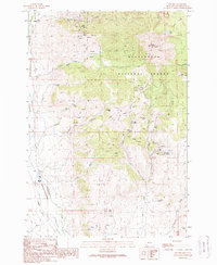
1988 Map of Polaris
USGS Topo · Published 1989About this map
Grasshopper Creek flows through this corner of the Beaverhead National Forest, where high-altitude mining operations define the historical landscape. The settlement of Polaris sits in the valley at the foot of massive terrain features like Baldy Mountain and Black Mountain. This 1988 provisional edition captures the extensive network of resource extraction that once dominated the area, from the Silver King Mine and Old Faithful Mine to the numerous adits and prospects scattered across the slopes of Garrett Hill.
Find a feature on this map
45 named features on this map. Tap any name to fly to it.
Don’t see what you’re looking for? This feature index may not catch every label — zoom into the map to look around manually.
Map Details
Editions of this 1988 Polaris Map
This is the sole edition of this map. No revisions or reprints were ever made.
Other maps of this area

1893 · Dillon
USGS Topo · 1:250,000

1952 · Bannack
USGS Topo · 1:24,000

1952 · Torrey Mountain
USGS Topo · 1:24,000

1952 · Ermont
USGS Topo · 1:24,000

1955 · Dillon
USGS Topo · 1:250,000

1957 · Dillon
USGS Topo · 1:250,000

1958 · Dillon
USGS Topo · 1:250,000

1959 · Polaris
USGS Topo · 1:62,500

1959 · Grant
USGS Topo · 1:62,500

1962 · Dillon
USGS Topo · 1:250,000