1944 Map of Polk City
USGS Topo · Published 1963About this map
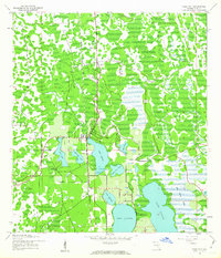
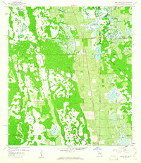
Polk City serves as the central hub of this mid-1940s landscape, positioned amidst a network of citrus groves and wetlands characteristic of interior Florida. The Seaboard Air Line railroad cuts vertically through the quadrangle, facilitating the movement of goods and passengers during a period of steady regional growth. To the west of the town center, the Mt Olive Ch stands as a local landmark near Mud Lake. The terrain is defined by a series of prominent water bodies including Lake Agnes, Lake Juliana, and Lake Mattie, the latter of which is bordered by the extensive Lake Mattie Marsh. Numerous Borrow Pits scattered across the northern and eastern sections suggest active road building and infrastructure development. Smaller lakes like Clearwater Lake, Lake Helene, and Lake Tennessee further illustrate the hydrology that dictated the placement of roads and homesteads in this part of Polk County.
Find a feature on this map
19 named features on this map. Tap any name to fly to it.
Don’t see what you’re looking for? This feature index may not catch every label — zoom into the map to look around manually.
Map Details
Editions of this 1944 Polk City Map
2 editions found
Other maps of this area
1944 · Providence
USGS Topo · 1:31,680
1944 · Polk City
USGS Topo · 1:31,680

1944 · Lakeland
USGS Topo · 1:31,680

1944 · Auburndale
USGS Topo · 1:31,680

1955 · Orlando
USGS Topo · 1:250,000

1957 · Orlando
USGS Topo · 1:250,000

1958 · Orlando
USGS Topo · 1:250,000
1959 · Gum Lake
USGS Topo · 1:24,000
1959 · Lake Louisa SW
USGS Topo · 1:24,000
1959 · Poyner
USGS Topo · 1:24,000