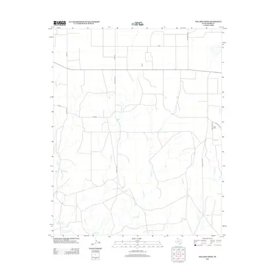
2012 Map of Pollard Creek
USGS Topo · Published 2012About this map
Pollard Cr and its numerous tributaries dominate this Moore County landscape, cutting a complex drainage network across the Texas Panhandle. The map reveals a region defined by its energy infrastructure and cattle ranching history, where the local road names reflect the industrial and family legacy of the area. Natural Gas Rd runs north-south through the center of the sheet, underscoring the importance of the gas fields to the local economy. In the northeast, Sneed Camp sits near the junction of Skelly School Rd and Ranch Road 1319, serving as a rare named settlement point in a territory otherwise marked by wide-reaching drainages like Turkey Cr and Bugbee Cr. To the southwest, the terrain descends toward the confluence of Big Blue Cr and Grapevine Cr, illustrating the rugged erosional patterns typical of the Canadian River watershed.
Find a feature on this map
19 named features on this map. Tap any name to fly to it.
Don’t see what you’re looking for? This feature index may not catch every label — zoom into the map to look around manually.
Map Details
Editions of this 2012 Pollard Creek Map
This is the sole edition of this map. No revisions or reprints were ever made.
Other maps of this area

1936 · Fourways
USGS Topo · 1:62,500

1939 · Sanford
USGS Topo · 1:62,500

1953 · Sanford
USGS Topo · 1:24,000

1953 · Evans Canyon
USGS Topo · 1:24,000

1953 · Spencer Draw
USGS Topo · 1:24,000

1954 · Amarillo
USGS Topo · 1:250,000

1958 · Amarillo
USGS Topo · 1:250,000
1970 · Sanford
USGS Topo · 1:24,000
1972 · Little Blue Creek
USGS Topo · 1:24,000

1972 · Dumas NE
USGS Topo · 1:24,000