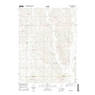
2015 Map of Pollock NW
USGS Topo · Published 2015About this map
Quinn and Terre Haute anchor this rural landscape in north-central Missouri, where the boundary between Putnam Co and Sullivan Co divides the southern portion of the sheet. The terrain is defined by a dense network of drainage, including Locust Creek and Brush Creek, which cut through the rolling topography. Smaller tributaries like Badger Branch, Rooks Branch, and Johnson Branch create a complex pattern of ridges and hollows that dictate the placement of local thoroughfares such as Mo-Ee and the many numbered township roads.
Find a feature on this map
57 named features on this map. Tap any name to fly to it.
Don’t see what you’re looking for? This feature index may not catch every label — zoom into the map to look around manually.
Map Details
Editions of this 2015 Pollock NW Map
This is the sole edition of this map. No revisions or reprints were ever made.
Other maps of this area

1942 · Seymour
USGS Topo · 1:62,500

1944 · Seymour
USGS Topo · 1:62,500

1954 · Centerville
USGS Topo · 1:250,000

1957 · Centerville
USGS Topo · 1:250,000

1958 · Centerville
USGS Topo · 1:250,000

1964 · Pollock NW
USGS Topo · 1:24,000

1964 · Harris
USGS Topo · 1:24,000

1964 · Unionville West
USGS Topo · 1:24,000
1964 · Pollock
USGS Topo · 1:24,000
1964 · Pollock SW
USGS Topo · 1:24,000