1950 Map of Pollock Pines
USGS Topo · Published 1965About this map
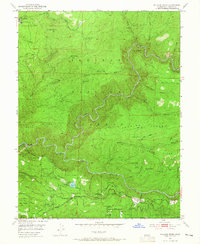
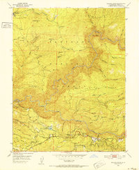
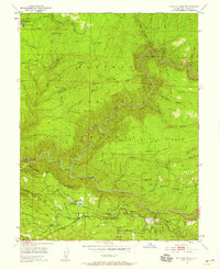
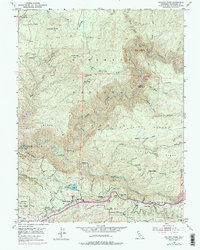
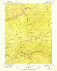
Pollock Pines serves as a central hub on this mid-century survey, situated just above the winding South Fork American River. The map reveals a landscape defined by timber and water management, marked by the presence of a Logging Railroad and the intricate route of the Blair Canal. Notable settlements and work sites including Pino Grande, Claussenius, and Ditch Camp Five point to the area's industrial activity, while the Bullion Bend Historic Marker identifies a site of local significance near Union Hill. High-elevation landmarks like Saddle Mtn and Chaix Mtn overlook deep drainages such as Silver Creek and Jay Bird Canyon. This record preserves the location of remote camps and mountain infrastructure, from the Telephone Line corridors to the Forebay and Pacific station, during a period when the Eldorado National Forest was actively managed for its natural resources.
Find a feature on this map
89 named features on this map. Tap any name to fly to it.
Don’t see what you’re looking for? This feature index may not catch every label — zoom into the map to look around manually.
Map Details
Editions of this 1950 Pollock Pines Map
4 editions found
Other maps of this area

1889 · Pyramid Peak
USGS Topo · 1:125,000

1891 · Placerville
USGS Topo · 1:125,000

1891 · Pyramid Peak
USGS Topo · 1:125,000

1892 · Placerville
USGS Topo · 1:125,000

1893 · Placerville
USGS Topo · 1:125,000

1895 · Pyramid Peak
USGS Topo · 1:125,000

1896 · Pyramid Peak
USGS Topo · 1:125,000

1947 · Sacramento
USGS Topo · 1:250,000

1948 · Sacramento
USGS Topo · 1:250,000
1950 · Riverton
USGS Topo · 1:24,000