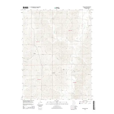
2014 Map of Pollock SW
USGS Topo · Published 2014About this map
Bairdston and Judson anchor this agricultural landscape in Sullivan County, where the terrain is deeply dissected by the winding course of Locust Creek. The map reveals a highly structured grid of rural roads—such as Montana Rd, Jolly Rd, and Locust Rd—that follow the section lines of the Public Land Survey System. These routes navigate around the numerous drainage features like Rooks Br and Elmwood Lbr. Genealogists will find the Hurst Cemetery positioned near the center of the quadrangle, serving as a landmark for local family histories. The presence of state routes Mo-Ee and Mo-BB indicates the primary corridors for transport and commerce in this northern Missouri region, connecting these small settlements to the broader county network.
Find a feature on this map
49 named features on this map. Tap any name to fly to it.
Don’t see what you’re looking for? This feature index may not catch every label — zoom into the map to look around manually.
Map Details
Editions of this 2014 Pollock SW Map
This is the sole edition of this map. No revisions or reprints were ever made.
Other maps of this area

1946 · Galt
USGS Topo · 1:62,500

1949 · Galt
USGS Topo · 1:62,500

1954 · Centerville
USGS Topo · 1:250,000

1957 · Centerville
USGS Topo · 1:250,000

1958 · Centerville
USGS Topo · 1:250,000

1964 · Pollock NW
USGS Topo · 1:24,000

1964 · Harris
USGS Topo · 1:24,000

1964 · Milan West
USGS Topo · 1:24,000
1964 · Milan East
USGS Topo · 1:24,000

1964 · Unionville West
USGS Topo · 1:24,000