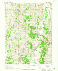
1964 Map of Pollock SW
USGS Topo · Published 1965About this map
Locust Creek and its many winding tributaries define this rural landscape in northern Missouri, where the townships of Clay, Jackson, Liberty, and Polk converge. The topography is characterized by a dense network of wooded ridges and stream valleys, notably Rooks Branch and West Locust Creek, which dictate the placement of early road networks and farmsteads.
Find a feature on this map
15 named features on this map. Tap any name to fly to it.
Don’t see what you’re looking for? This feature index may not catch every label — zoom into the map to look around manually.
Map Details
Editions of this 1964 Pollock SW Map
This is the sole edition of this map. No revisions or reprints were ever made.
Other maps of this area

1946 · Galt
USGS Topo · 1:62,500

1949 · Galt
USGS Topo · 1:62,500

1954 · Centerville
USGS Topo · 1:250,000

1957 · Centerville
USGS Topo · 1:250,000

1958 · Centerville
USGS Topo · 1:250,000

1964 · Pollock NW
USGS Topo · 1:24,000

1964 · Harris
USGS Topo · 1:24,000

1964 · Milan West
USGS Topo · 1:24,000
1964 · Milan East
USGS Topo · 1:24,000

1964 · Unionville West
USGS Topo · 1:24,000