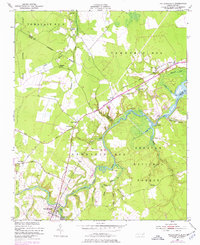
1950 Map of Pollocksville
USGS Topo · Published 1977About this map
The Trent River dominates this mid-century survey of coastal North Carolina, winding through a landscape of creek-fed bottomlands and dense woodlands within the Croatan National Forest. The town of Pollocksville serves as the primary hub, situated near where the Seaboard Coast Line railroad crosses the river. The map reveals an economy and community still closely tied to the water, as evidenced by a string of riverside landmarks including Bells Landing, Scott Landing, Debruhls Landing, and Tar Landing.
Find a feature on this map
49 named features on this map. Tap any name to fly to it.
Don’t see what you’re looking for? This feature index may not catch every label — zoom into the map to look around manually.
Map Details
Editions of this 1950 Pollocksville Map
3 editions found
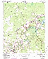
Other maps of this area

1901 · New Bern
USGS Topo · 1:62,500

1903 · New Bern
USGS Topo · 1:62,500

1903 · Trent River
USGS Topo · 1:62,500

1904 · Trent River
USGS Topo · 1:62,500

1942 · Maysville
USGS Topo · 1:62,500

1943 · Jacksonville
USGS Topo · 1:62,500

1948 · Maysville
USGS Topo · 1:62,500

1950 · Pollocksville
USGS Topo · 1:24,000

1950 · New Bern
USGS Topo · 1:24,000

1953 · Rocky Mount
USGS Topo · 1:250,000