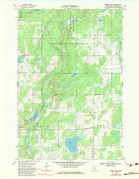
1968 Map of Pomroy Lake
USGS Topo · Published 1983About this map
The Snake River meanders through the heart of this Kanabec County landscape, carving its way through the Snake River State Forest and the bordering townships of Ford, Kroschel, and Pomroy. This 1960s survey documents a region defined by its conservation areas, including the Bean Dam State Wildlife Management Area and the Hay-Snake State Wildlife Management Area. These protected zones reflect a late mid-century focus on preserving the North Woods' wetlands and river corridors.
Find a feature on this map
18 named features on this map. Tap any name to fly to it.
Don’t see what you’re looking for? This feature index may not catch every label — zoom into the map to look around manually.
Map Details
Editions of this 1968 Pomroy Lake Map
2 editions found
Other maps of this area

1953 · Duluth
USGS Topo · 1:250,000

1953 · Stillwater
USGS Topo · 1:250,000

1955 · Stillwater
USGS Topo · 1:250,000

1958 · Stillwater
USGS Topo · 1:250,000

1958 · Duluth
USGS Topo · 1:250,000

1961 · Brook Park
USGS Topo · 1:62,500

1965 · Stillwater
USGS Topo · 1:250,000

1968 · Kroschel NW
USGS Topo · 1:24,000

1968 · Mora North
USGS Topo · 1:24,000

1968 · Pomroy Lake
USGS Topo · 1:24,000