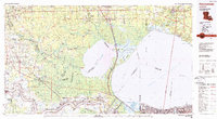
1983 Map of Ponchatoula
USGS Topo · Published 1984About this map
Lake Pontchartrain dominates the southeastern portion of this landscape, its waters bridged by the iconic Lake Pontchartrain Causeway. The surrounding geography is defined by a dense network of waterways and wetlands, including the expansive Lake Maurepas and the winding course of the Mississippi River near Donaldsonville. This 1980s-era survey reveals the delicate balance between the natural cypress-tupelo environments like Gum Swamp and the human engineering required for industry and transport. The Illinois Central Gulf Railroad and Kansas City Southern Railway cut through the marshes, facilitating movement between the established settlements of Ponchatoula, Hammond, and the river parishes. Large conservation areas such as the Manchac Wildlife Management Area and Fontainebleau State Park highlight the preservation of the basin's ecological character amidst the growth of coastal Louisiana.
Find a feature on this map
66 named features on this map. Tap any name to fly to it.
Don’t see what you’re looking for? This feature index may not catch every label — zoom into the map to look around manually.
Map Details
Editions of this 1983 Ponchatoula Map
2 editions found
Other maps of this area

1891 · Hahnville
USGS Topo · 1:62,500

1891 · Spanish Fort
USGS Topo · 1:62,500

1891 · New Orleans
USGS Topo · 1:62,500

1892 · Lac Des Allemands
USGS Topo · 1:62,500

1892 · Chef Menteur
USGS Topo · 1:62,500

1892 · Mount Airy
USGS Topo · 1:62,500

1892 · Bonnet Carre
USGS Topo · 1:62,500

1892 · Donaldsonville
USGS Topo · 1:62,500

1892 · St. Bernard
USGS Topo · 1:62,500

1892 · Thibodaux
USGS Topo · 1:62,500