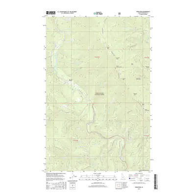
2017 Map of Pond Peak
USGS Topo · Published 2017About this map
The North Fork Coeur d'Alene River carves through the heart of the Coeur d'Alene National Forest, defining a landscape of high summits and deep drainages. In this northern Idaho interior, the Shoshone Ridge serves as a massive spine between the river and the Shoshone Range. A network of Forest Service routes, such as Beetle Creek Rd and the Nat For Dev Rd 948, provides access to these peaks, including the prominent Pond Peak and Sentinel Peak. The presence of Big Hank Meadow along the river's edge suggests one of the few level breaks in the steep terrain, likely serving as a localized hub for backcountry travel or timber management. Numerous smaller tributaries like Big Hank Cr and Swift Cr feed the main river channel, illustrating the complex watershed that characterizes the Coeur d'Alene Mountains.
Find a feature on this map
62 named features on this map. Tap any name to fly to it.
Don’t see what you’re looking for? This feature index may not catch every label — zoom into the map to look around manually.
Map Details
Editions of this 2017 Pond Peak Map
This is the sole edition of this map. No revisions or reprints were ever made.
Other maps of this area

1909 · Cataldo
USGS Topo · 1:125,000

1911 · Cataldo
USGS Topo · 1:125,000

1932 · Trout Creek
USGS Topo · 1:125,000

1935 · Trout Creek
USGS Topo · 1:125,000

1936 · Trout Creek
USGS Topo · 1:125,000

1955 · Spokane
USGS Topo · 1:250,000

1956 · Wallace
USGS Topo · 1:250,000

1957 · Burke
USGS Topo · 1:62,500

1957 · Kellogg
USGS Topo · 1:62,500

1958 · Spokane
USGS Topo · 1:250,000