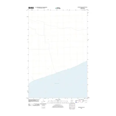
2010 Map of Ponemah NW
USGS Topo · Published 2010About this map
Upper Red Lake dominates the southern portion of this 2010 survey, showing the shoreline transition as it meets the low-lying northern interior. Produced by the U.S. Geological Survey, this quadrangle illustrates a landscape characterized by its sparse development and significant hydrography. The map provides a precise look at the northern reaches of one of Minnesota's most significant inland water bodies, documenting the shoreline as it existed at the start of the decade. The lack of named inland settlements or landmarks highlights the natural state of the terrain surrounding the lake, offering a clear view of the topography before any further modern encroachment.
Find a feature on this map
1 named feature on this map. Tap any name to fly to it.
Don’t see what you’re looking for? This feature index may not catch every label — zoom into the map to look around manually.
Map Details
Editions of this 2010 Ponemah NW Map
This is the sole edition of this map. No revisions or reprints were ever made.
Other maps of this area

1918 · F
USGS Topo · 1:62,500

1919 · G
USGS Topo · 1:62,500

1919 · Ponemah
USGS Topo · 1:62,500

1943 · Ponemah
USGS Topo · 1:62,500

1954 · Roseau
USGS Topo · 1:250,000

1957 · Roseau
USGS Topo · 1:250,000

1958 · Roseau
USGS Topo · 1:250,000

1973 · Manomin Creek SE
USGS Topo · 1:24,000

1973 · Manomin Creek
USGS Topo · 1:24,000
1973 · Sucker Creek
USGS Topo · 1:24,000