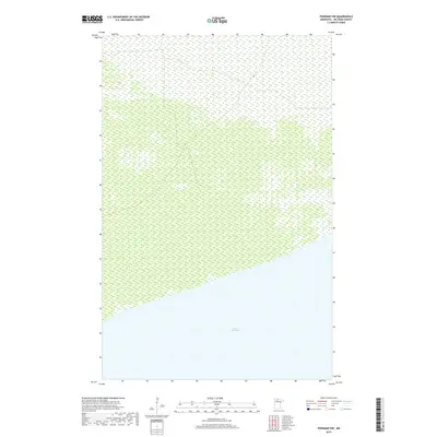
2019 Map of Ponemah NW
USGS Topo · Published 2019About this map
Upper Red Lake dominates the southern reaches of this landscape, its northern shoreline cutting a distinct diagonal across the township boundaries. The map defines a transition between the vast aquatic expanse and the northern wetlands of Beltrami County, illustrated by the intricate hydrography dataset of the region. Surveyed as part of the Public Land Survey System, the area is organized into four distinct townships: t155n r34w, t155n r33w, t154n r33w, and t154n r34w. The northern terrain consists primarily of dense marshlands and wetland inventories, offering a detailed look at the unpopulated wilderness stretching away from the lake's edge. This 2019 edition provides critical documentation of the lake's shoreline before subsequent environmental shifts, serving as a baseline for environmental and geological study of northern Minnesota.
Find a feature on this map
5 named features on this map. Tap any name to fly to it.
Don’t see what you’re looking for? This feature index may not catch every label — zoom into the map to look around manually.
Map Details
Editions of this 2019 Ponemah NW Map
This is the sole edition of this map. No revisions or reprints were ever made.
Other maps of this area

1918 · F
USGS Topo · 1:62,500

1919 · G
USGS Topo · 1:62,500

1919 · Ponemah
USGS Topo · 1:62,500

1943 · Ponemah
USGS Topo · 1:62,500

1954 · Roseau
USGS Topo · 1:250,000

1957 · Roseau
USGS Topo · 1:250,000

1958 · Roseau
USGS Topo · 1:250,000

1973 · Manomin Creek SE
USGS Topo · 1:24,000

1973 · Manomin Creek
USGS Topo · 1:24,000
1973 · Sucker Creek
USGS Topo · 1:24,000