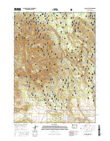
2017 Map of Ponina Butte
USGS Topo · Published 2017About this map
Ponina Butte and the Black Hills define the high country of this Klamath County landscape, which remains largely under the stewardship of the Fremont National Forest. The map documents a transition from industrial logging to modern recreation, most notably through the Woods Line Rails-to-Trails, which follows a former timber railway grade across the southeast corner. The terrain is deeply carved by drainage systems including Ponina Cr, Mill Cr, and Fivemile Cr, with numerous isolated water sources like Lonesome Pond and Mill Creek Spring dotting the forest. Evidence of the area's resource management and access is found along Five Mile Creek Rd and Sycan Rd, which navigate the draws and ridges of the high desert plateau.
Find a feature on this map
31 named features on this map. Tap any name to fly to it.
Don’t see what you’re looking for? This feature index may not catch every label — zoom into the map to look around manually.
Map Details
Editions of this 2017 Ponina Butte Map
This is the sole edition of this map. No revisions or reprints were ever made.
Other maps of this area

1889 · Klamath
USGS Topo · 1:250,000

1894 · Klamath
USGS Topo · 1:250,000

1955 · Klamath Falls
USGS Topo · 1:250,000

1958 · Klamath Falls
USGS Topo · 1:250,000

1960 · Riverbed Butte
USGS Topo · 1:62,500

1960 · Bly
USGS Topo · 1:62,500

1960 · Beatty
USGS Topo · 1:62,500

1960 · Fuego Mountain
USGS Topo · 1:62,500

1980 · Williamson River
USGS Topo · 1:100,000
1988 · Riverbed Butte Spring
USGS Topo · 1:24,000